

OVP's Aerial Imagery Services supports Commercial / Residential Real Estate, Commercial, and Government Contracts. We are
SBE, SLBE, MBE, & FAA Part 107 certified


At OVP, we provide professional Geo-referenced Drone solutions that deliver actionable insights, accurate data, and high-quality visual assets. Services include aerial photography & videography, LiDAR scanning, photogrammetry, thermal imaging, 3D mapping, DEM, and more. Our Aerial Media services are designed to support projects of all sizes. You may contact us for a custom proposal built specifically for your project requirements.
LIDAR
LiDAR (Light Detection and Ranging) provides Geo-Referenced precision 3D data point cloud. Used to create a wide range of data rich 2D and 3D maps & models. LiDAR captures highly accurate elevation and terrain data, even through vegetation and complex environments. LiDAR mapping delivers precise surface models and geospatial data for surveying, engineering, infrastructure, and environmental projects.

PHOTOGRAMMETRY
Photogrammetry utlizes 4k cameras to transform overlapping aerial imagery into geo-referenced 2D maps and 3D models using advanced photogrammetry processing. This technology provides precise measurements, site analysis, and visual datasets for construction, engineering, and planning applications.
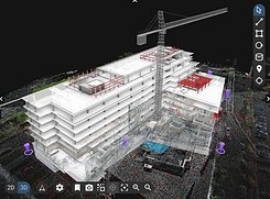
POINT CLOUD
A highly accurate, geo-referenced set of 3D data points (X, Y, Z coordinates) that maps the topography, terrain, and built environment from above. Captured using LiDAR sensors or photogrammetry, they are widely used for infrastructure planning, site modeling, and risk assessments.

THERMAL
Thermal sensors inspections used to detect heat loss, moisture intrusion, electrical issues, and equipment anomalies that may not be visible to the naked eye. Thermal imaging provides a safer and more efficient way to identify problems early and support preventative maintenance

ORTHOMOSAIC
A highly accurate, geometrically corrected aerial map that provides a true top-down view of an area, free from distortions and perspective errors. Created by stitching multiple overlapping photos together using photogrammetry software.

3D MAPPING
Detailed and interactive 3D maps that provide a comprehensive view of terrain, structures, and project sites. Drone-based 3D mapping improves visualization, planning accuracy, and collaboration between project teams and stakeholders.

VOLUMETRIC ANALYSIS
Measure stockpiles, excavation quantities, and material volumes quickly and accurately using drone-generated data. Volumetric reporting helps improve inventory management, reduce manual surveying time, and support better project cost control.

DIGITAL ELEVATION MODEL (DEM)
Create detailed digital elevation models to analyze terrain, drainage, grading, and site topography. DEM data supports planning, earthwork calculations, and infrastructure development with accurate surface elevation insights.

CONSTRUCTION PROGRESSION
Capturing repeatable aerial photos, videos, or 3D maps at regular intervals (e.g., weekly or monthly). This creates a powerful visual timeline to track project milestones, monitor safety, and keep stakeholders informed.

AERIAL SITE IMAGERY
Capture high-resolution aerial photos and video to document site conditions, track project progress, and provide stakeholders with a complete overhead perspective. Drone imagery improves communication, enhances reporting, and creates a reliable visual record throughout every phase of construction or development.


